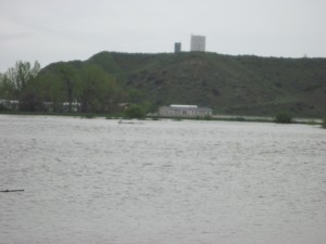
Flooding along Interstate 94 from the Pryor Creek. This image was taken off Pryor Creek Road looking at the water tower above the town of Huntley. The area of water was a field of hay.
So many have either seen or heard about the Pryor Creek flooding and boy did it flood! It started last week with misty rain during the day with burst of showers every little bit. However, the Pryor Mountains received 5+ inches of rain and with record slow pack in the mountains, made for a lot more water flooding down the Pryor Creek and nearby streams going into the town of Huntley, MT. The last big flooding for Huntley and the Pryor Creek was in 1978 but residents say it was about 2 feet higher in 1978. Bridges, roads and structures have either flooded or been washed away completely. The following videos were taken Sunday, May 22, 2011 along Interstate 90 and 94.
This evening, the Montana Department of Transportation closed off Pryor Creek Road temporarily as they were analyzing the damage caused to the Pryor Creek bridge and might open up the road in 5-6 hours but chances are slim as more water is upstream on it’s way down. Montana Rail link was hard at work deterring the water from threatening the railroad. Montana Rail link was inserting boulders into the water to help prevent erosion on the railroad tracks. If the flooding did close the railroad from running, it could cost a decrease of revenue that would be collected to the State of Montana. It was reported that each coal train leaving Montana in generating $25,000 in revenue. In other words, little businesses and Big businesses affected by the flooding and erosion are affected which affects the taxpayers in the long run.
The Red Cross and emergency personnel from Yellowstone County have organized some shelters for those who were evacuated in Huntley and mainly the Blue Creek/Briarwood area at the LDS church building. The Church of Jesus Christ of Latter-days building located at 1711 South Billings, Blvd will be the shelter until the water returns back to its banks. As of this time, there were reported some 30 people that had registered at the shelter. There was also loads of sand dumped to sandbag locations for those who wanted to but few have taken advantage of the opportunity of sandbags at this time.
As it rained in the Pryor Mountains, the heavy snow pack with rain helped melt a record amount of water down the mountains and streams. The town of Pryor was flooded as well as Crow Agency was declared an emergency and disaster area as the interstate was closed going to Wyoming.

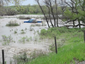
The driver of this truck tried to drive through water going over the road and it swepted him away and now the truck is a loss as seen in the picture.
There were however some residents who braved the mysterious water that was going over the road and lost. One particular person decided to drive his truck along Squaw Creek road and the the driver of the truck did not see that the road was washed out and ended up with a truck off the road. The picture explains it better a result of the incident.
Update: As road closures have been issued, Local residents, businesses and schools have been affected. Especially those in and around the Huntley area. As the Pryor Creek bridge connecting I-94 to the town of Huntley is closed, local business have closed or been affected in many ways. For starters, the local businesses like R and R Trading, the Huntley Express Way, Sonrise Espresso and the Pryor Creek Cafe were and will be affected due to the lack of traffic being able to pass by. However, some businesses like the Pryor Creek Cafe and the R and R hardware had lots of traffic and cars in the parking lot.
Road closures also affected the local area not only for the residents and homes but the local Huntley Project School District. As impromptu school bus routes were changed, other routes were modified in order to get the students on one side of the bridge to school while trying to arrange another bus route to pick up the rest of the students.
All school buses that went up Pryor Creek had to use Interstate 94 at Ballantine in order to reach the Pryor Creek Golf course and Yellowstone Trail Road areas. Parts of the Pryor Creek Golf Course were under flood waters at this time. Due to heavy rain fall on the Pryor Mountains, melted snow on the mountain also resulted in the downstream flooding. In addition to road closures and due to the Little Big Horn River flooding in Hardin and Crow Agency, local tourism business Western Romance Company had tours that were canceled due to the flood waters in Hardin, Lodge Grass and Crow Agency areas. Other flooding in the state affected the towns of Harlowtown, Roundup, Forsythe, Pompeys Pillar, and Glendive. As road closures in other parts of the state are completed, the domino affect of the tourism industry is also affected down the road as was the case for the Western Romance Adventure company. Hopefully, the Department of Transportation will be able to safely open interstate travel soon so the rest of the next 4 tour bus holdups this week for the company will be completed.
———————————————————————
Check with the weather page for updated info and conditions.

1 comment for “Pryor Creek / Blue Creek Flooding – 2011”